As per the latest update on IMD’s official post on X, Cyclone Montha [pronounced Mon-Tha], which had intensified into a Severe Cyclonic Storm over the Bay of Bengal earlier this week, has now weakened into a Cyclonic Storm after making landfall over the coastal districts of Andhra Pradesh. According to the India Meteorological Department (IMD), the system continues to move northwestwards and is expected to gradually lose strength over the next several hours, even as another weather disturbance, a Depression over the East Central Arabian Sea, continues to develop in parallel.
Landfall completed; cyclone weakens
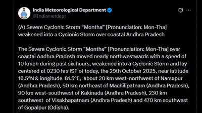 At 2:30 a.m. IST on October 29, the cyclonic storm Montha was positioned approximately 20 km west-northwest of Narsapur, 50 km northeast of Machilipatnam, 90 km west-southwest of Kakinada, and 230 km southwest of Visakhapatnam. IMD confirmed that the cyclone had weakened from a Severe Cyclonic Storm to a Cyclonic Storm as it moved inland.
The system is expected to continue its northwestward trajectory across coastal Andhra Pradesh. IMD also suggests that it will maintain its current intensity for the next six hours before weakening further into a deep depression.
The storm’s weakening, however, has not diminished the risk of severe weather over the region. Heavy to very heavy rainfall continues to lash parts of Krishna, East Godavari, and West Godavari districts, while strong winds persist in coastal belts. The IMD has warned of localised flooding, uprooted trees, and damage to houses, electric poles, and power lines in some areas.
Weather predictions post Cyclone MonthaThe India Meteorological Department’s (IMD) All India Weather Summary and Forecast Bulletin, issued on October 28 and valid till November 3, projects a prolonged spell of rain, thunderstorms, and gusty winds over large parts of the country. The ongoing influence of Severe Cyclonic Storm “Montha”, currently weakening after landfall near Kakinada in Andhra Pradesh, along with a developing Depression over the East Central Arabian Sea, is expected to shape the nation’s weather pattern for much of this week.
According to the IMD, scattered to fairly widespread rainfall is forecast over southern, eastern, and northeastern India, while isolated showers are expected across the northwest. No significant temperature fluctuations are likely in most regions over the next five to seven days.
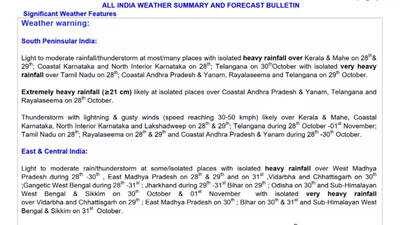
On October 29, heavy to very heavy rainfall is likely over Odisha, Andhra Pradesh, Telangana, Vidarbha, Chhattisgarh, and Saurashtra and Kutch, with isolated extremely heavy downpours over parts of Odisha. The IMD has also predicted heavy rainfall in Bihar, Jharkhand, Madhya Pradesh, Maharashtra, Kerala, and coastal regions including Konkan and Goa.
As Cyclone Montha weakens and moves inland, its associated moisture will push the rainfall belt northwards. On October 30, Bihar, East Madhya Pradesh, East Uttar Pradesh, and Saurashtra and Kutch are likely to experience heavy to very heavy rainfall, while Arunachal Pradesh, Assam, Meghalaya, Jharkhand, Odisha, Chhattisgarh, Telangana, and Vidarbha may receive heavy rain.
Thunderstorms with gusty winds reaching 40–50 kmph are forecast over East Uttar Pradesh, with slightly lower wind speeds over adjoining eastern and northeastern states. Squally winds are also expected along the Gujarat and Konkan coasts as well as over the Bay of Bengal, driven partly by the Arabian Sea depression’s circulation.
The IMD warns of potential flash floods and minor road damage in Bihar, Jharkhand, and Madhya Pradesh as heavy rains intensify over the Gangetic plains and central India.
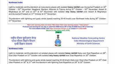
By October 31, the weather activity will gradually extend to northeastern India. Arunachal Pradesh, Assam, Meghalaya, Bihar, Sub-Himalayan West Bengal, and Sikkim are expected to record heavy to very heavy rainfall, while Nagaland, Manipur, Mizoram, and Tripura will witness isolated heavy showers.
In western India, Saurashtra and Kutch will continue to see heavy rainfall due to the influence of the Arabian Sea system, which will maintain strong squally winds along the Gujarat and north Konkan coasts.
As the week progresses, the focus of rainfall shifts decisively to the northeastern states. On November 1, Arunachal Pradesh, Assam & Meghalaya are forecast to experience heavy to very heavy rain, while Nagaland, Manipur, Mizoram, Tripura, and Sub-Himalayan West Bengal and Sikkim will receive heavy showers.
By November 2 and 3, activity will taper off gradually, but Assam and Meghalaya will continue to receive moderate to heavy rainfall. No significant thunderstorm or wind activity is expected beyond isolated lightning in the region.
As for the cyclone affected coastal regions, fishermen have been advised to stay away from the sea, as sea conditions continue to remain rough to very rough along the Andhra Pradesh and Odisha coasts. The storm surge, though moderate due to the cyclone’s reduced strength, is still expected to inundate low-lying areas near the coast, especially around Kakinada and Machilipatnam.
With the Arabian Sea depression also under close observation, India’s coastal states are bracing for a few more days of turbulent weather and heightened precautionary measures.
Landfall completed; cyclone weakens
The system is expected to continue its northwestward trajectory across coastal Andhra Pradesh. IMD also suggests that it will maintain its current intensity for the next six hours before weakening further into a deep depression.
The storm’s weakening, however, has not diminished the risk of severe weather over the region. Heavy to very heavy rainfall continues to lash parts of Krishna, East Godavari, and West Godavari districts, while strong winds persist in coastal belts. The IMD has warned of localised flooding, uprooted trees, and damage to houses, electric poles, and power lines in some areas.
Weather predictions post Cyclone MonthaThe India Meteorological Department’s (IMD) All India Weather Summary and Forecast Bulletin, issued on October 28 and valid till November 3, projects a prolonged spell of rain, thunderstorms, and gusty winds over large parts of the country. The ongoing influence of Severe Cyclonic Storm “Montha”, currently weakening after landfall near Kakinada in Andhra Pradesh, along with a developing Depression over the East Central Arabian Sea, is expected to shape the nation’s weather pattern for much of this week.
According to the IMD, scattered to fairly widespread rainfall is forecast over southern, eastern, and northeastern India, while isolated showers are expected across the northwest. No significant temperature fluctuations are likely in most regions over the next five to seven days.
On October 29, heavy to very heavy rainfall is likely over Odisha, Andhra Pradesh, Telangana, Vidarbha, Chhattisgarh, and Saurashtra and Kutch, with isolated extremely heavy downpours over parts of Odisha. The IMD has also predicted heavy rainfall in Bihar, Jharkhand, Madhya Pradesh, Maharashtra, Kerala, and coastal regions including Konkan and Goa.
As Cyclone Montha weakens and moves inland, its associated moisture will push the rainfall belt northwards. On October 30, Bihar, East Madhya Pradesh, East Uttar Pradesh, and Saurashtra and Kutch are likely to experience heavy to very heavy rainfall, while Arunachal Pradesh, Assam, Meghalaya, Jharkhand, Odisha, Chhattisgarh, Telangana, and Vidarbha may receive heavy rain.
Thunderstorms with gusty winds reaching 40–50 kmph are forecast over East Uttar Pradesh, with slightly lower wind speeds over adjoining eastern and northeastern states. Squally winds are also expected along the Gujarat and Konkan coasts as well as over the Bay of Bengal, driven partly by the Arabian Sea depression’s circulation.
The IMD warns of potential flash floods and minor road damage in Bihar, Jharkhand, and Madhya Pradesh as heavy rains intensify over the Gangetic plains and central India.
By October 31, the weather activity will gradually extend to northeastern India. Arunachal Pradesh, Assam, Meghalaya, Bihar, Sub-Himalayan West Bengal, and Sikkim are expected to record heavy to very heavy rainfall, while Nagaland, Manipur, Mizoram, and Tripura will witness isolated heavy showers.
In western India, Saurashtra and Kutch will continue to see heavy rainfall due to the influence of the Arabian Sea system, which will maintain strong squally winds along the Gujarat and north Konkan coasts.
As the week progresses, the focus of rainfall shifts decisively to the northeastern states. On November 1, Arunachal Pradesh, Assam & Meghalaya are forecast to experience heavy to very heavy rain, while Nagaland, Manipur, Mizoram, Tripura, and Sub-Himalayan West Bengal and Sikkim will receive heavy showers.
By November 2 and 3, activity will taper off gradually, but Assam and Meghalaya will continue to receive moderate to heavy rainfall. No significant thunderstorm or wind activity is expected beyond isolated lightning in the region.
As for the cyclone affected coastal regions, fishermen have been advised to stay away from the sea, as sea conditions continue to remain rough to very rough along the Andhra Pradesh and Odisha coasts. The storm surge, though moderate due to the cyclone’s reduced strength, is still expected to inundate low-lying areas near the coast, especially around Kakinada and Machilipatnam.
With the Arabian Sea depression also under close observation, India’s coastal states are bracing for a few more days of turbulent weather and heightened precautionary measures.
You may also like

Tottenham boss Thomas Frank facing midfield dilemma after Newcastle injury blow
Rishab Shetty thanks his direction squad for 'standing strong' with him
Gold Silver Price Update: Gold Down ₹13,000 from Record High, Silver Falls ₹23,000 — What's Next for Investors?
Not even the US or EU: Why Mexico alone gets a 180-day multiple-entry Visit Visa in the UAE
Who is sending death threats and demanding jail time for TikTok star Kaz Sawyer after his Singapore pool video?


